Section 2.1.3
Section 2.1.3 Other Tables
Other table prefixes are used within the database, mainly S_*. These tables are used for a variety of purposes but are not generally accessed directly by a user (outside of specific software). Those tables not described in Section 2.1.1 or 2.1.2 (or this section) are unused in this version of the database (and are empty) or are SiteFX specific. Many of these will be related to SiteFX’s sample or history tracking/management capability.
S_USER
This table is exclusively used by SiteFX for user tracking.
Though also mentioned in Section 2.1.3 (Other; below), this table also contains the ‘range’ of numeric identifiers available to each partner agency (refer also to V_SYS_S_USER_ID_RANGES). This allows data to be input at each partner agency without the possibility of primary key conflicts when synchronizing between partner agencies. Note that the changeover from a database replication sharing to a remote (and web) database access has reduced the importance of this feature.
Users/partners using SiteFX will automatically be limited to their own range (note that these are keyed by the user-login which should be specific to the partner agency; all logins for a particular agency will be given the same range of values). The users of alternative software must take care that any keys used created for the import of data correspond to their particular partner agency range (refer to the views V_SYS_RANDOM_ID_* for this purpose).
The ranges of values are shown in the following table.
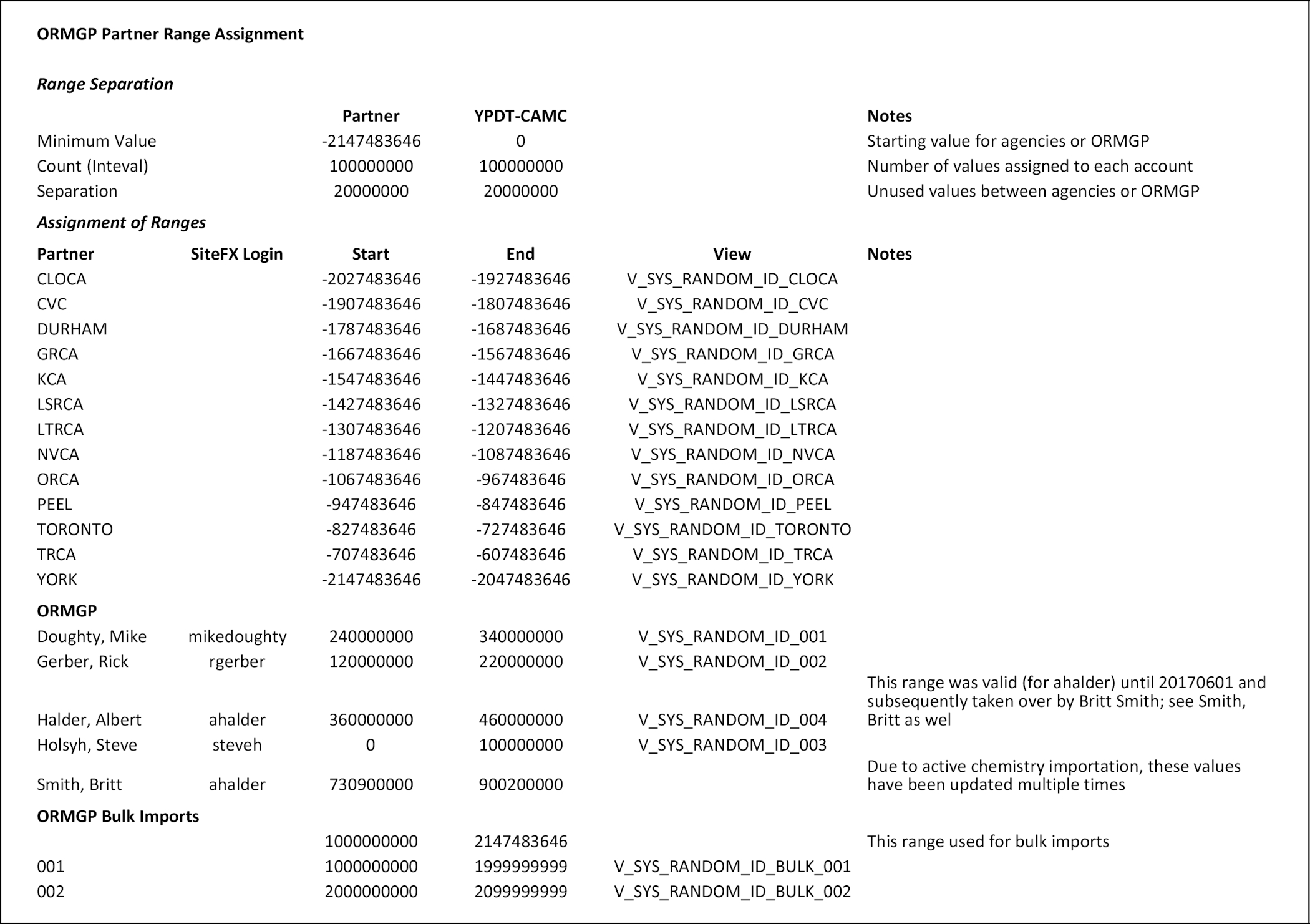 Table 2.1.3.1 Range of identifiers assigned to partner agencies and users.
W_GENERAL
Each of the W_* data tables contain summaries of information used specifically for ‘web’ access, especially with regard to online mapping (almost all contain a GEOM field for coordinates as well as each of a CA_ID, REG_ID and SWP_ID relating to the contained area in which the location lies). Each of the tables includes a GIS_ID field with values greater than zero - such a key is required by the mapping backend software (Geocortex - Latitude Geographics, 2017; and ArcGIS - ESRI, 2017).
This table contains ‘general’ location information, mainly focused on boreholes. Temporal data availability and ranges is also listed. This is related to D_LOCATION using LOC_ID.
Note that all ‘W_*’ tables are automatically re-populated weekly and rely upon information present in the D_LOCATION_SUMMARY and D_INTERVAL_SUMMARY tables (though not exclusively).
Field - GEOL_FEAT
This field is used to assemble the ‘Water Found’ information as commonly defined on the MOE water-well master sheets. As more than one water type can be specified, these have been converted to a text-string of 0/1 values such as ‘001001’. For additional details, refer to the description of V_SYS_W_GENERAL_GEOL_FEAT (which assembles the data for this field).
W_GENERAL_DOCUMENT
This table contains information from the D_LOCATION and D_DOCUMENT tables and includes a formatted bibliographic reference field (BIBLIO). This is related to D_LOCATION using LOC_ID. Refer to W_GENERAL, above, for information concerning the ‘W_’ tables.
W_GENERAL_GROUP
This table contains information regarding the various groupings (and types) of wells (as found in D_GROUP_LOCATION and related tables).
W_GENERAL_GW_LEVEL
This table contains daily averages of water levels as well as (if available) manual water levels for any interval with more than 25 records. This table is used in conjunction with W_GENERAL_SCREEN for plotting purposes. This is related to D_LOCATION using LOC_ID and D_INTERVAL using INT_ID. Refer to W_GENERAL, above, for information concerning the ‘W_’ tables.
W_GENERAL_OTHER
This table contains summary information for non-borehole locations as specified in the field TYPE (e.g. Climate Stations and Surface Water Stations). It is related to D_LOCATION using LOC_ID and D_INTERVAL using INT_ID. Refer to W_GENERAL, above, for information concerning the ‘W_’ tables.
W_GENERAL_PICK
This table contains the picks (as found in D_PICK) as well as associated information.
W_GENERAL_SCREEN
This table contains summary information for screened intervals (i.e. screened well intervals) as described in R_INT_TYPE_CODE (above). It is related to D_LOCATION using LOC_ID and D_INTERVAL using INT_ID. This table is used as a locational reference for information in W_GENERAL_GW_LEVEL. Refer to W_GENERAL, above, for information concerning the ‘W_’ tables.
Last Modified: 2023-05-03