Section 3.3.1
Section 3.3.1 Naming Conventions
When naming a new location that is being added into the database it is important to consider (other) users of the database finding a well using the names that you assign to any/all of the LOC_NAME, LOC_NAME_ALT1 or LOC_ORIGINAL_NAME fields. In the past it was found that assigned names were too ambiguous (e.g. MW #6) and, as a result, wells were being added to the database on more than one occasion with varying names, thus creating duplicate records in the database. A final naming field, LOC_MAP_NAME, is used primarily for spatial (e.g. map) display purposes where length of name (i.e. as short as possible) is necessary to limit overlapping of text. No other specific guideline is provided.
The LOC_STUDY field can be used to assist in grouping and locating wells that may be tied to a certain study, for example a particular development application. It is recommended that the LOC_STUDY field be populated for any new wells added to the database.
The following should be considered when naming locations in the database:
-
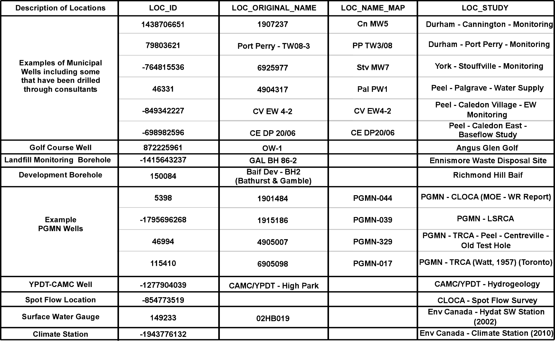
In the D_LOCATION table, the LOC_ORIGINAL_NAME field should always contain the MOE ID as first priority; where no MOE ID exists, an historical name can be substituted (e.g. the consultant name); in cases where a well is subsequently updated with an MOE ID, the LOC_ORIGINAL_NAME should be updated (i.e. overwritten) to reflect this MOE ID number; for these cases, the old LOC_ORIGINAL_NAME entry could, if not already captured in the LOC_NAME or LOC_NAME_ALT1 fields, be moved into the D_LOCATION_ALIAS table
-
Geographical references should be relatively specific - e.g. ‘Heart Lake Rd. well’ as opposed to ‘CVC well’ or ‘Grasshopper Road well’ versus ‘CLOCA well’
-
Where the naming of existing locations are inconsistent with what is proposed here they will be slowly renamed to follow the above conventions; all users are encouraged to assist with implementing consistent naming conventions (if they spot erroneously named locations); when in doubt, contact ORMGP staff
-
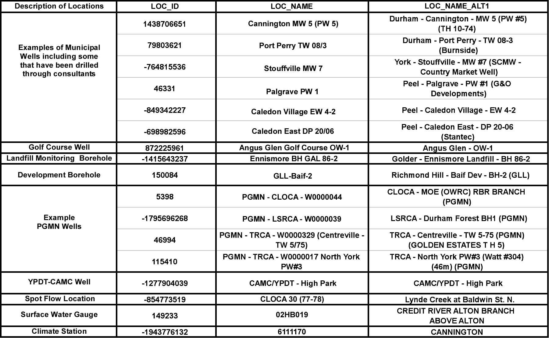
For new municipal wells it is recommended that users follow the current naming strategy of prefixing the well name with the community name in the LOC_NAME field (e.g. King City PW 1). The LOC_NAME_ALT1 field for municipal wells also contains the Region (e.g. York - King City - PW 1); if a future database user is looking for a York Region well there should be absolutely no problem with finding it using these conventions; many municipal wells also have a local name which can also be added to the name (e.g. a LOC_NAME of ‘Aurora MW 7 (Henderson TW)’; a LOC_NAME_ALT1 of ‘York - Aurora MW#7 - Henderson TW (GLL)’).
-
For municipal and consultant drilled wells, the following prefixes are recommended:
- PW (Pumping Well) - currently used, previously used, and backup pumping wells should be designated with a PW (for wells in Durham the MW, indicating ‘Municipal Well’, prefix is also incorporated - e.g. a LOC_NAME of ‘Blackstock MW 3 (PW 3)’; a LOC_NAME_ALT1 of ‘Durham - Blackstock - MW #3 (PW #3)’)
- TW (Test Well) or TH (Test Hole) - an exploration well that was unsuccessful and has been abandoned is typically referred to as a test well and should be given a TW prefix; it is worth noting that there are exceptions since at times these exploration wells are not abandoned but, rather, left in place as longer term monitoring wells - the TW moniker remains with the well; note that the TW prefix is preferred over the TH prefix
- BH (Borehole) - this prefix should be given to any borehole where a screen is installed for monitoring purposes (water levels and/or water quality); however, unlike longer term monitoring (MW) wells (see below), these are generally intended for a short term life (e.g. those wells drilled on proposed development sites that subsequently get abandoned)
- MW (Monitoring Well) - current or previously used monitoring wells from which water levels or water quality data have been derived are typically designated with an MW prefix
- EW (Early Warning Well) or SW (Sentry Well) - these prefixes can be used for the subset of monitoring wells that are specifically used to look at the water quality in wellhead protection areas; note that the LOC_TYPE_CODE of ‘1’ (i.e. ‘Well or Borehole’) would differentiate these wells from surface water monitoring locations which have, instead, a LOC_TYPE_CODE of ‘6’ (i.e. ‘Surface Water’), and (frequently) an SW prefix
- DP (Drive Point) or MP (Mini-Piezometer) - these prefixes are applied to temporary drive points or mini-piezometers that are pounded by hand into the shallow subsurface (often in stream beds or in wetlands or adjacent to these features) to provide an indication of SW/GW interactions; typically they are short-lived, however they can remain in place as active monitoring locations for years; note that in the case of a mini-piezometer in a stream where the water levels both inside and outside of the pipe are recorded, it is recommended that the outside measurement be tied to a ‘Staff Gauge’ station (i.e. SG, see below) as opposed to an MP station; within the database the two stations (e.g. an MP and SG) can be linked together through the LOC_MASTER_LOC_ID field and can also be grouped using the D_GROUP_LOCATION table
- SG (Staff Gauge) - the prefix is to be used where a staff gauge is placed into a water body (e.g. a lake, stream or wetland) to measure the elevation/depth of the water levels over time; the prefix should also be used in the case of a mini-piezometer where the water level is measured on the outside of a mini-piezometer pipe; generally these staff gauges are temporary - however, when they are attached to a bridge (over/in a river) or other infrastructure they can remain in place for years
- SW (Surface Water) - this prefix can be used for both spot flow as well as gauged surface water stations
- CS (Climate Station) - this prefix can be used for any climate station that is established for short or long term monitoring purposes
It is important to note that the status of municipal or consultant drilled wells can change over time. For example, pumping wells can be abandoned or converted to monitoring wells or vice-versa. In such cases the prefix should be changed and the former name (with the earlier prefix designation) can be stored in the D_LOCATION_ALIAS table. Alternatively, to clearly identify that the well was converted, the former prefix can also be saved in parenthesis at the end of the current name. Decommissioned pumping wells should retain the PW prefix indefinitely and the name should not be changed. The LOC_STATUS_CODE (in D_LOCATION) should be changed from ‘Active’ (i.e. a value of ‘1’) to ‘Decommissioned’ (i.e. a value of ‘7’; refer to R_LOC_STATUS_CODE for details).
Examples are provided in the following table (broken into two sections for readability). Refer also to the D_LOCATION table outline in Section 2.1.1.
 Table 3.3.1.1 D_LOCATION naming
conventions (LOC_NAME and LOC_NAME_ALT1).
 Table 3.3.1.2 D_LOCATION naming
conventions (LOC_ORIGINAL_NAME, LOC_NAME_MAP and LOC_STUDY).
