Bedrock Geology
The underlying Paleozoic bedrock in the study area was deposited on top of the Canadian Shield rocks over a period of 200 million years, beginning approximately 550 million years ago. Sediments from the erosion of the Taconic and Appalachian mountains, two ranges that formed from earlier mountain building events, infilled the Michigan Basin with limestone and shale units, which now underlie the study area. The map below shows the various bedrock formation units that underlie the glacial sediments in the study area. This is schematically shown on the Figure below taken from Ontario Rocks (Eyles, 2002).
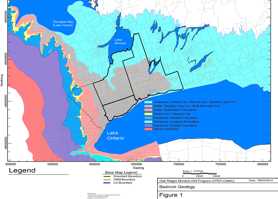
The various bedrock formation units that underlie the glacial sediments in the study area.
Erosion of the Bedrock Surface
Within the study area, the bedrock surface reflects an unconformity. Eyles (2002) has speculated that as much as seven kilometers of bedrock material could have been eroded during the last 150 million years. The historic Laurentian River system, is likely responsible for a significant part of the bedrock erosion in the area immediately east of the Niagara Escarpment.
Since first proposed by Spencer in 1881, the Laurentian River system has been noted and delineated by different Ontario geoscientists (e.g. White and Karrow, 1971, Brennand et al, 1998). In this part of south-central Ontario, the Laurentian River – believed to have been a main drainage pathway for a significant portion of the Great Lakes Basin – flowed from the Wasaga Beach area at Georgian Bay southwards through Simcoe County and York Region to Toronto where it has been traced into the Lake Ontario basin. Bedrock topography maps prepared by the Ontario Geological Survey through the 1960s and 1970s reflected this Laurentian River system as well as its tributaries (e.g. White, 1968, Rogers et al, 1961), although not necessarily as one complete drainage system. A recent Provincial interpretation of the bedrock surface has also been prepared by Gao (2006). The map below shows the topography on the bedrock surface as interpreted in 2003-2006 by Oak Ridges Moraine Groundwater program staff. The map shows the deep depression of the Laurentian River extending northwestwards from the Toronto area.
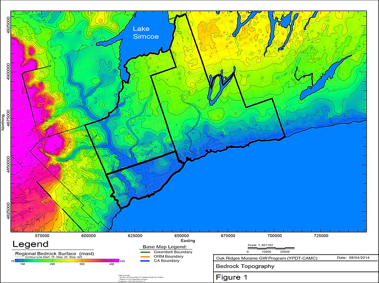
Bedrock topography of the Laurentian river system in South-Central Ontario.