Hydrostratigraphic Units
Geologic layers or formations are often classified into Hydrostratigraphic Units for analysis during hydrogeologic investigations. A hydrostratigraphic unit is a geologic formation, part of a formation, or a group of formations with similar hydrologic characteristics or properties (e.g. hydraulic conductivity or permeability) relating to groundwater flow. Hydrostratigraphic units are then classified into aquifer or aquitard units (Freeze and Cherry, 1979; Domenico and Schwartz, 1990; Fetter, 2001). Fluids flow more readily through aquifer units (e.g. sand and gravel) compared to aquitard units (e.g. clay). Ultimately a single geologic layer or formation may be subdivided into multiple hydrostratigraphic units, including both aquifers and aquitards.
The geologic layers and how they have been mapped within the study area is described elsewhere. The interpreted geologic layers and the hydrostratigraphic classification within the study area are summarized on Figure 1. Note that this interpretation is subject to refinement as new subsurface information becomes available. From youngest to oldest, the current hydrostratigraphic unit interpretation is as follows:
- Glaciolacustrine deposits (sand, silt and clay): aquifer or aquitard;
- Halton/Kettleby Aquitard;
- Oak Ridges Aquifer Complex (ORAC);
- Regional Unconformity – tunnel channel infill deposits;
- Newmarket Diamict;
- Upper Newmarket till (aquitard);
- Inter-Newmarket sediments (aquifer);
- Lower Newmarket till (aquitard);
- Thorncliffe Aquifer Complex (TAC) or equivalent;
- Sunnybrook Aquitard (or equivalent);
- Scarborough Aquifer Complex (SAC) or equivalent; and
- Bedrock (aquifer or aquitard).
Currently, efforts are underway to explore the subdivision of the Oak Ridges Moraine sediments into multiple hydrostratigraphic units. The Don Formation and underlying York Till have not been mapped throughout the study area because of the paucity of deep detailed information that would be necessary to delineate these deposits. It is also possible that these deposits may simply be restricted to small geographic areas where they were not eroded away. It should be noted that local occurrences of a basal till at great depth have been noted beneath the Oak Ridges Moraine at Uxbridge and west of Lake Simcoe which may in fact be coeval with the York Till. In general, possible occurrences of Don Formation sands have been included in with Scarborough Sands while possible occurrences of York Till have been included in with silt and clay of the Scarborough Aquifer Complex in the Toronto area.
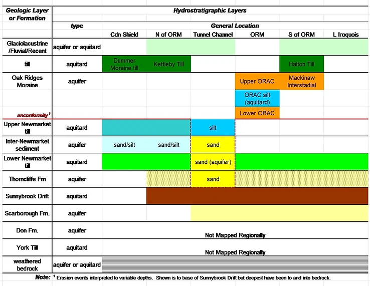
Figure 1: Interpreted geologic and hydrostratigraphic units.
The term “aquifer complex” is used to signify a unit with mostly moderate to high permeability sediments (e.g. sand and gravel) that may or may not be laterally continuous but are likely derived from similar depositional processes. For example, the term Thorncliffe Aquifer Complex is used to describe material that is believed to be mostly within the Thorncliffe Formation (or equivalent) that is mainly sand and silty sand but also includes smaller-scale bodies of silt or silty clay. The term “or equivalent” has been used to extend the stratigraphic nomenclature established in studies along the Lake Ontario shoreline (e.g. Karrow, 1967; Brookfield et al., 1982; Eyles, 1987) northwards to the Lake Simcoe area. For instance, the term Sunnybrook Aquitard (or equivalent) is used to describe aquitard material separating deposits of the Thorncliffe Aquifer Complex from the Scarborough Aquifer Complex. Because there is limited information available on the deeper units, it is not known for certain whether the various aquifer units that occur within the Lower Sediments of the study area are exactly the same as those described along the Lake Ontario shore. However, the extension of the nomenclature used at the Scarborough Bluff “type section” provided a common reference framework into which aquifers and aquitards were placed and referenced.
For the study area east of the Niagara Escarpment, there are basically three major aquifer systems that are included within the Quaternary sediments situated above bedrock. These can be further classified according to relative depth into one shallow aquifer system and two deep aquifer systems. The shallow aquifer system occurs within sediments of the Oak Ridges Moraine, Inter-Newmarket unit north of the moraine, and Mackinaw Interstadial unit south of the moraine, and occurs above the laterally extensive Lower Newmarket till aquitard. The two deep aquifer systems are associated with the sediments of the Thorncliffe and Scarborough geologic formations, and occur beneath the Lower Newmarket till aquitard. Locally where Quaternary sediments are thin the limestone bedrock is utilized as the local aquifer.
The term Tunnel Channels refers large-scale subglacial events that often have eroded through the Lower Newmarket till and possibly through deeper geologic units (Figure 2). The nature of the infill sediments and the magnitude and direction of vertical hydraulic gradients controls the amount of leakage between the shallow flow system and the deep flow system. The infill for one tunnel channel system, located near King City and Nobleton, is described in detail by Russell et al. (2002). A conceptual rendering of groundwater flow through tunnel channel sediments with assumed downward vertical hydraulic gradients is shown on Figure 3. Mapping of tunnel channels within the study area is described in Russell et al., 2003.
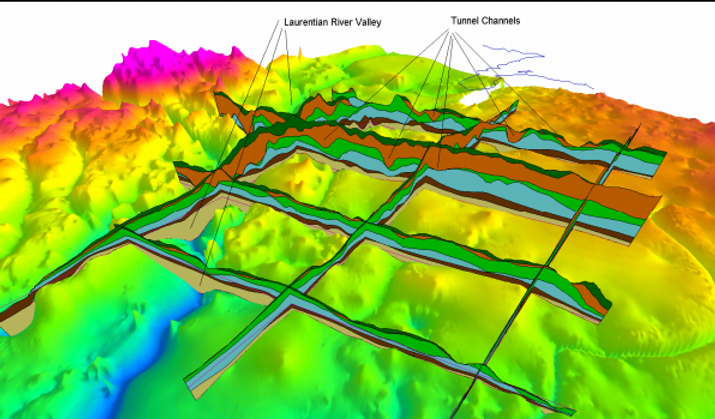
Figure 2: Bedrock surface and fence diagram of sediment layers. (View from Toronto looking northwest. Width of 3‑D viewport is approximately 150 km.). From Earthfx, 2006.
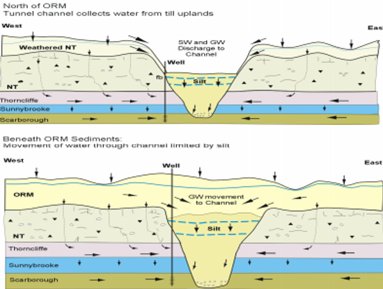
Figure 3: Conceptual function of the tunnel channel sediments. From Earthfx, 2006 which was modified from Sharpe et al., 2002.
Not all geologic and hydrostratigraphic units are present everywhere throughout the study area. For example the Scarborough, Sunnybrook and Thorncliffe geologic units which contain the two deep aquifers largely occur as in-fill within the broad bedrock valley system trending from Georgian Bay southwards to Toronto. These three geologic units are sometimes referred to as Lower Sediments (Sharpe et al., 2005). As shown on Figure 4, the Lower Sediments are interpreted to pinch out in the west as the bedrock surface rises along the Niagara Escarpment and they also pinch out to the northeast and east as the bedrock surface rises near the Canadian Shield. In the locations where the units are pinching out upon the rising bedrock surface they become increasingly confined to tributary bedrock valleys. The shallow aquifer system is thickest where it occurs within sediments of the Oak Ridges Moraine (Figure 5). Localized sand bodies occurring beneath the surficial till to the north of the Oak Ridges Moraine have been mapped as Inter-Newmarket sediments, with variable hydraulic connection to the Oak Ridges Moraine Aquifer Complex (ORAC). To the south of the moraine sands and gravel deposits occurring between the Halton and Lower Newmarket till deposits have been mapped as Mackinaw Interstadial sediments. These sediments are largely localized within lower elevations on the surface of the Lower Newmarket till. Hydraulic connection with the ORAC diminishes southward away from the moraine.
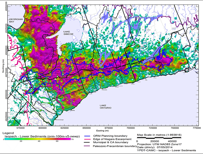
Figure 4: Interpreted thickness (m) of Lower Sediments (Scarborough Fm, Sunnybrook Drift, and Thorncliffe Fm).
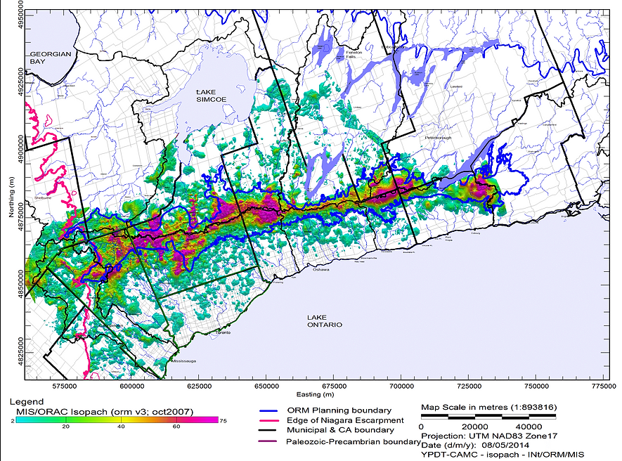
Figure 5: Interpreted thickness (m) of Inter-Newmarket sediments north of ORM, Oak Ridges Moraine sediments, and Mackinaw Interstadial sediments south of the moraine. Refinement in northwest and northeast map areas in progress.