Sedimentology
The study area is covered mostly by unconsolidated glacial sediments that have been deposited over the past approximately 200,000 years. Over 200 m of these sediments can be found in the study area; however, there are also many places where glacial sediments are nearly absent and bedrock is exposed at ground surface. Areas of thin to no sediment cover are particularly common in the northeast, where Canadian Shield rocks outcrop, but also above the Niagara Escarpment in the west and along the Lake Ontario shoreline where Paleozoic bedrock outcrops. The thickest unconsolidated glacial sediments are found in the area where the Oak Ridges Moraine overlies the Laurentian Channel, a deeply incised bedrock trough extending from the Wasaga Beach area in the northwest to the Toronto area in the southeast. At the intersection of these features, in the area just northwest of King City, the unconsolidated sediments overlying bedrock reach a maximum estimated thickness of about 250 m.
The map below shows the interpreted thickness of the glacial sediments in the southern part of the study area.
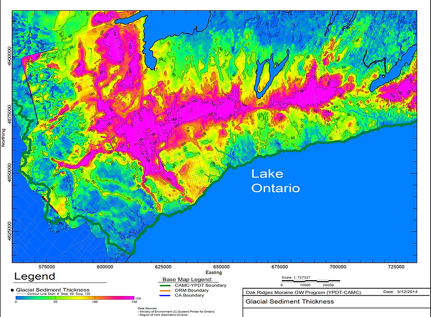
A map of the interpreted thickness of the glacial sediments in the southern part of the ORMGP study area.
The stratigraphic framework of these glacial sediments has been developed by the Geological Survey of Canada (Sharpe et al., 1999) with six key elements:
- Bedrock
- Lower Sediments
- Newmarket Till
- Channel Fill
- Oak Ridges Moraine
- Halton Till
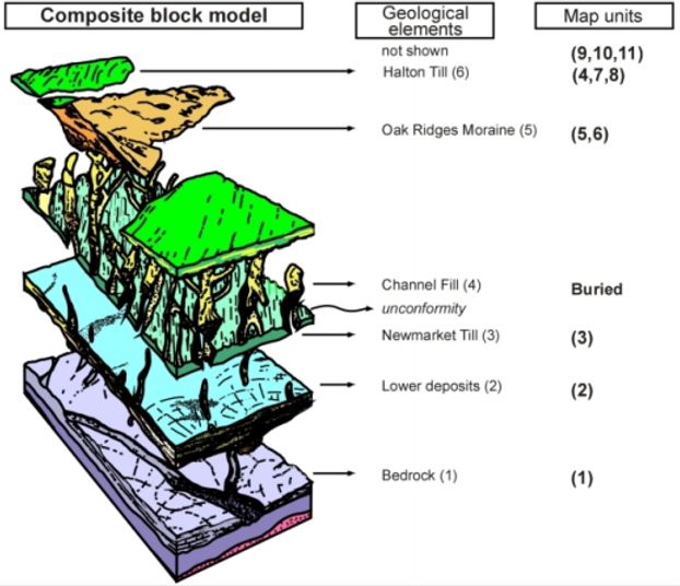
Image of the six glacial sediment layers overlying the ORMGP study area.
A more comprehensive stratigraphic sequence is outlined in the figure below. This shows that the Geological Survey of Canada (GSC)’s lower sediments can be sub-divided into three units:
- Thorncliffe Formation
- Sunnybrook Drift
- Scarborough Formation
Also, two earlier deposited units, the Don Formation and the York Till, are found underlying the Lower Sediments of the GSC. Both of these units predate the onset of Wisconsinan glaciation, the period during which the bulk of the sediments occurring in the study area were deposited. The Wisconsinan glaciation started some 80,000 years ago and reached its maximum about 20,000 years ago.
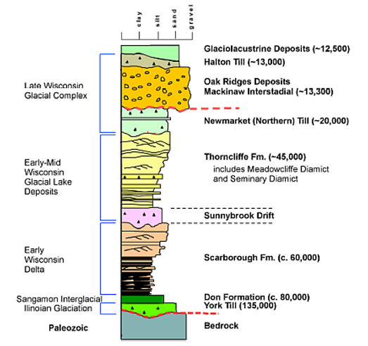
Stratigraphic Model of Quaternary Deposits (from Eyles, N. 2002. Ontario rocks: Three billion years of environmental change. Fitzhenry & Whiteside Ltd.)
In more recent geological interpretations two slight alterations have been made to the conceptualized geological model as outlined above.
In areas to the north of the Oak Ridges Moraine, within York and Durham Regions, it was found that the Newmarket Till was frequently divided into two units with an intervening coarser granular (silt, sand or gravel) unit (e.g., the Durham Model Report, York Tier 3 Report). As a result the Newmarket Till has been divided into an “Upper” and “Lower” section with an “Inter-Newmarket Sediment” layer separating the two.
Within the Oak Ridges Moraine sediments it was found that a silt unit could be picked as a distinct lower permeability unit within the Oak Ridges Aquifer package.
Whether these changes become entrenched in the longer term conceptual geological model for the area remains to be seen.