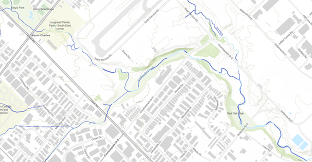
Modelled Groundwater Discharge to Streams
The Modelled Groundwater Discharge to Streams is found on the “Surface Water” theme map. When turned on, parts of the stream network are visible, as shown in the figure below. The reaches shown are those that have been interpreted, through a numerical groundwater modelling process, to be areas where the groundwater is actively discharging into the surface water network. The thickness of the stream segment reflects the amount of groundwater discharge with the thinnest lines reflecting a discharge of less than 5 L/s per km of stream and the thickest lines reflecting a discharge of over 25 L/s per km length of stream. Where no line appears, the modelling suggests that there is no groundwater being discharged to the stream.
With over 80 numerical models available under the ORMGP umbrella, there is certainly no shortage of models to choose from. Currently, there are three numerical models reflected on the ORMGP Surface Water Map theme. The Regional Model was chosen since it has the greatest areal coverage of any of the numerical models available. It extends from below the Niagara Escarpment in the west right to the Trent River in the east and from the Lake Ontario shoreline northwards to the Kawartha Lakes. The model, developed in the early 2000s, is a five-layer model with a cell size of 240 m x 240 m. The Regional Model (along with the more detailed – but geographically restricted Core Model) is discussed in detail in the Regional/Core Model Report. Since the Regional Model does not extend to west to Halton Region, the Halton Hills Tier 3 (Halton Hills Tier 3 Report) and the South Halton Source Water Protection model were used in these areas.