Wetland Hydrologic Screening Tool
Purpose, Method and Treatment of Wetland Groups
Purpose and Context
The Ontario Wetland Evaluation System (OWES) provides the provincial framework for evaluating wetland functions and determining wetland significance. The evaluation considers four major components: Biological, Social, Hydrological and Special Features and relies on a combination of field observations, existing information, mapping and professional judgement. OWES evaluations must ultimately be undertaken and attested to by a trained wetland evaluator.
The ORMGP Wetland Hydrologic Screening Tool was developed to automate the spatially intensive calculations associated with the flood attenuation portion of the OWES Hydrological Component. The intent is not to replace an OWES evaluation or the judgement of a qualified evaluator. Rather, the tool provides a rapid, consistent and reproducible means of assembling the watershed information needed to support the OWES calculation and to screen large numbers of wetlands across the Oak Ridges Moraine Groundwater Program (ORMGP) jurisdiction.
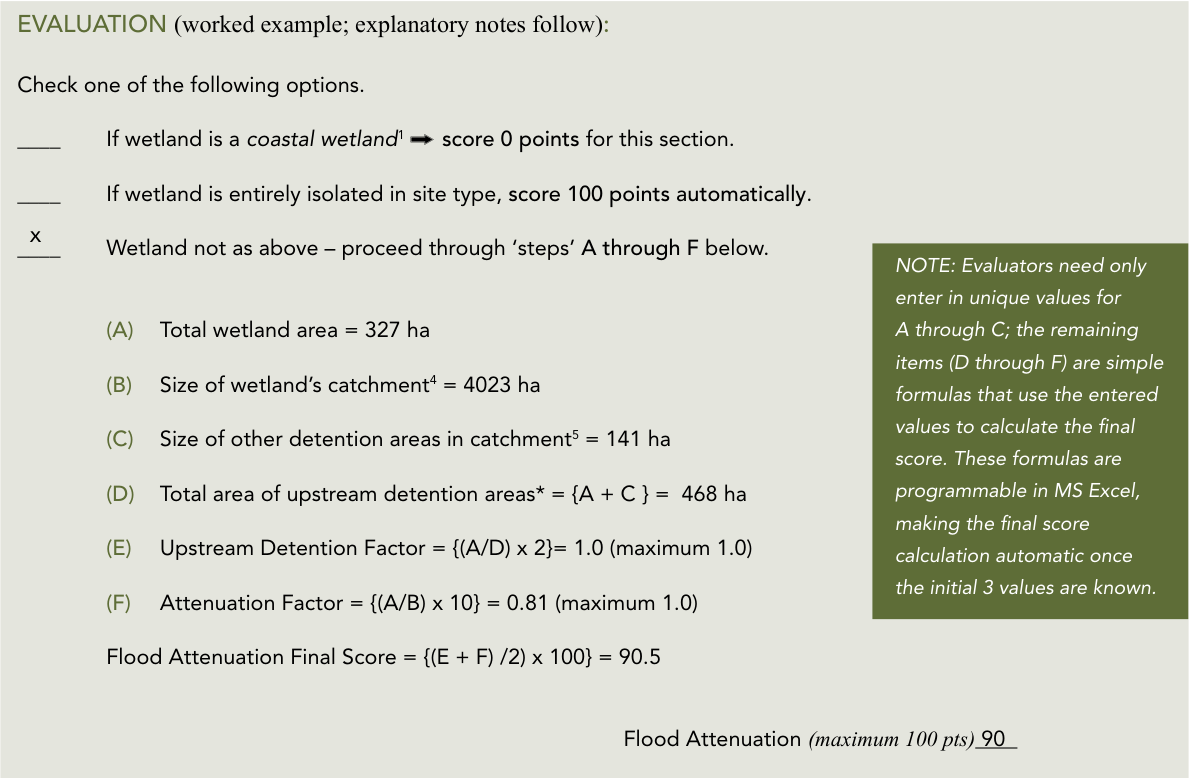
Under OWES, flood attenuation is evaluated using three principal spatial characteristics: the area of the wetland, the area of its upstream catchment, and the area of other detention features within that catchment. These relationships are used to assess how effectively a wetland can reduce downstream flood peaks. The ORMGP tool automates the determination of these spatial inputs and applies the OWES scoring calculations. The presentation developed for the tool identifies the required inputs as wetland area, wetland catchment area, other detention areas within the catchment, and connectivity or proximity to major waterbodies.
Interactive Mapping Tool
Full-screen mode available in the top-left corner
How the Tool Works
A key capability underlying the application is automated drainage-area delineation. The ORMGP’s terrain-processing workflow uses a digital elevation model to establish flow directions and drainage connectivity. Depression filling and treatment of flat areas are applied before flow paths are calculated, allowing a catchment to be delineated automatically to a selected location.
For wetlands, the original point-based drainage-area tool was modified so that a user selecting a location within a mapped wetland does not simply receive the area draining to that individual point. Instead, the application identifies the wetland and delineates the drainage area contributing to the wetland as a whole. Within that catchment, the tool identifies other wetlands and waterbodies that may provide upstream detention and calculates their areas.
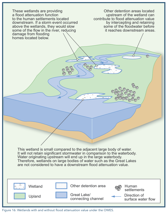
This directly reflects the OWES flood-attenuation methodology. OWES requires evaluators to consider all detention areas in the basin, not just features directly connected to an inflowing stream. Detention areas can include other wetlands (including isolated wetlands) as well as lakes, large rivers, reservoirs, ponds and flooded pits or quarries. The OWES Wetland Evaluation Data and Scoring Record then combines wetland area, catchment area and other detention areas to calculate the Upstream Detention Factor and Wetland Attenuation Factor, which together determine the flood attenuation score.
The screening application currently operates across approximately 126,700 mapped wetlands, uses provincial wetland mapping by default, and can accommodate alternative or more detailed wetland mapping supplied by ORMGP partners. Results are available through an interactive Shiny/Leaflet application (see above) and can also be accessed programmatically through a REST API.
Treatment of Wetland Groups
An important implementation consideration is determining what constitutes the wetland being evaluated, particularly where mapped wetland polygons are divided by roads, railways or other narrow non-wetland features.
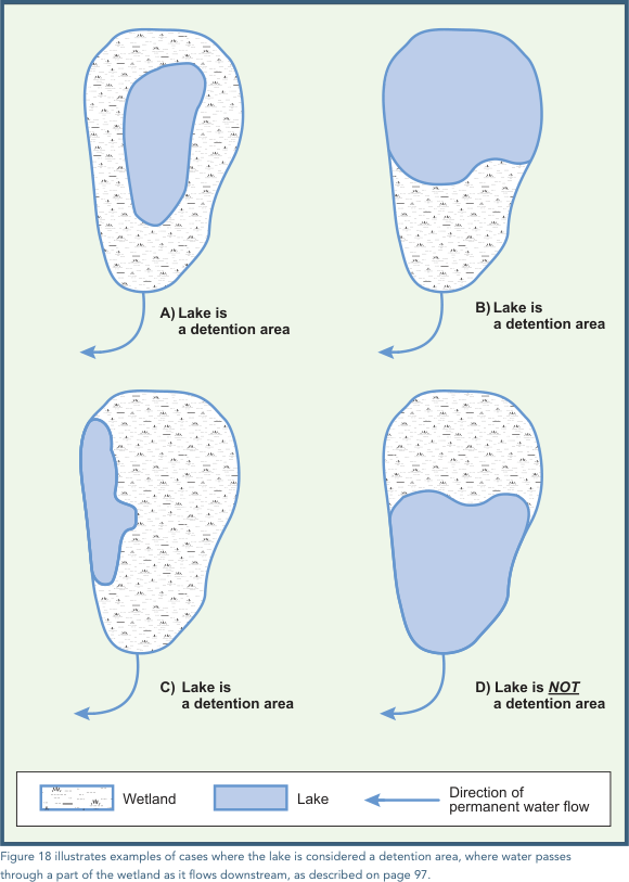
OWES clearly recognizes that a wetland does not necessarily have to consist of a single homogeneous vegetation polygon. A Wetland Unit is defined as “a single wetland or a contiguous group of wetland communities,” surrounded by non-wetland areas. The manual also explicitly recognizes situations in which closely grouped wetlands function together as one. Examples include clusters of small wetland ponds separated by small upland pockets and wetlands along a lake or river separated by short distances. In these circumstances, OWES directs that the features be evaluated as one wetland rather than as separate individual wetlands.
For purposes of the screening tool, however, mapped wetland polygons are treated independently rather than being automatically grouped into larger wetland units. Where a road, railway, upland area, or other mapped feature separates wetland polygons, each polygon is evaluated as a separate wetland feature based on its mapped geometry. The tool therefore does not attempt to infer whether adjacent or closely spaced polygons are hydrologically or functionally connected.
This approach represents a deliberate divergence from the evaluator-based interpretation permitted under OWES. Evaluating mapped polygons independently provides a consistent and reproducible screening basis and preserves the spatial distinctions present in the source wetland mapping. It should not, however, be interpreted as a conclusion that wetlands separated by roads, railways, or other narrow features are necessarily hydrologically independent. In a detailed OWES evaluation, an evaluator may determine that two or more mapped polygons form part of the same functional wetland and should be considered together.
Intended Use
The ORMGP Wetland Hydrologic Screening Tool is therefore best viewed as a decision-support and pre-screening application. It automates calculations that would otherwise require substantial GIS processing, applies those calculations consistently across a large regional wetland inventory, and provides evaluators with transparent information on wetland area, contributing catchment, upstream detention and hydrologic context. It can substantially reduce the effort required to undertake the hydrologic portion of an OWES assessment while leaving wetland delineation, interpretation of unusual circumstances, verification of hydrologic connectivity and the final OWES determination with the qualified wetland evaluator.
OWES excerpts from
Ontario Ministry of Natural Resources and Forestry (MNRF). 2022. Ontario Wetland Evaluation System: Southern Manual. 4th Edition. King’s Printer for Ontario, Peterborough, Ontario. link